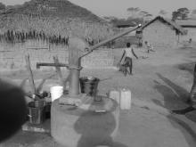
Almost 4,000 records have been added in Liberia, providing new insights to the water point landscape in this country. The new data builds on roughly 10,000 records collected during an earlier water point survey. These updates include water points in communities and schools across the country.
The 2011 Waterpoint Mapping project was carried out using smartphone-based survey software Akvo FLOW. Akvo FLOW is a software tool that collects, manages, analyses and displays geographically referenced monitoring and evaluation data using mobile phones. It lets users create simple or complex surveys on any topic. Since 2013, the system has been used to update the water point information and the newly added data is a result of those updates.
You can access the new data here!
