Rwanda and Zambia data now available on WPdx+ Tools app

We are pleased to announce that WPdx data and decision-support analyses for Rwanda and Zambia are now available on the WPdx Decision Tools web app. For more information on the WPdx Decision Support Tools, please review this blog post. To review and access the WPdx-Basic and WPdx+ datasets, please go the Access Data page.

To zoom directly to the country view on the WPdx Decision Support Tools web app, please click the links below:

Rwanda: 8,590 individual water points with contributions of more than 100 records from Living Water International, WaterAid, Water for People, and World Vision. The majority of data is located in Kicukiro, Gicumbi and Rulindo districts.

Zambia: 5,511 individual water points with contributions of more than 100 records from Living Water International, SNV Zambia, UNHCR, Village Water, WaterAid, Water4, World Vision, and UNHCR.

The coverage and quality of available data will continue to improve as others share data through the platform.

Looking for help to upload your data? Reach out to info@waterpointdata.org today!

Digitizing data collection for improved data access and analytics in Gulu, Uganda

Photo credit: Stellamaris Nakacwa

With contributions from Stella Nacakwa, M.S. Candidate, West Virginia University & Courtney Clark, YouthMappers.

The Gulu University chapter of YouthMappers, in partnership with YouthMappers, West Virginia University, the Water Point Data Exchange (WPdx) and the U.S. Agency for International Development (USAID) have been collaborating on the Uganda Water Infrastructure Mapping Project (U-WIMP). For additional information on the project, please see here. Briefly, the project identified two complementary goals including:

  • building the technical capacity of Ugandan YouthMappers in both mapping and spatial decision-support analysis, and
  • demonstrating the possibilities for making evidence-based decisions through the collection of digitized water data and the application of cutting-edge data analytics to district and regional government officials and partners.

During the winter of 2021/2022, students receiving training on the following topics:

  • Geospatial concepts and principles
  • Analyzing satellite imagery to identify buildings, roads, and other features
  • Editing OpenStreetMap (OSM) using the JOSM (Java OpenStreetMap) editor and the Humanitarian OpenStreetMap (HOT) Tasking Manager
  • Conducting fieldwork to collect data using Kobo Collect on smartphones
  • Understanding structures and processes related to Water, Sanitation, and Hygiene (WASH) in Uganda
  • The importance of developing and implementing digital systems for WASH in Uganda, including an introduction to WPdx.

Data Collection with KoboCollect

In late May, a team including 30 student members from the Gulu University Chapter of YouthMappers, two Gulu University professors, and members from YouthMappers headquarters completed a mapping exercise to collect data on the water points in two sub-counties in Gulu District, Uganda: Bungatira and Unyama. The team utilized a customized KoboCollect app downloaded onto smart phones to collect a suite of parameters based on the WPdx Data Standard. The parameters included:

  • GPS location (#lat_deg, #lon_deg),
  • Date of Visit (#report_date)
  • Administrative division (#adm)
  • Type of water point (#water_source, #water_tech)
  • Functionality status (#status_id)
  • Management type (#management)
  • Subjective water quality (#subjective_quality)
  • Installation date (#install_year)
  • Photograph (#photo)

Automating Uploads to WPdx

Over the course of two weeks, the field team collected over 600 water data points from 26 villages in Gulu District. These data are now freely available through WPdx’s database and decision support tools. Through a connection between the KoboCollect API and the WPdx ingestion engine, data was


automatically uploaded each day, allowing a near-real time view of the available data on the WPdx Decision Support Tools app. In addition to water point data, more than 15,000 buildings and 1,400 square kilometers of roads for these villages in Gulu were digitized using OSM, and this geographic data is freely accessible to the local government, NGOs, and the public to use for not only water infrastructure projects but any project requiring an accurate, digital base map.

This project demonstrated a digital waterpoint data collection process that made the data available freely and openly online, in near real-time. The project improves upon the current paper-based data collection process by introducing simple digital tools that leverage mobile technologies and cloud platforms to collect and store field data. The project was not an attempt to replicate a full water point census, but rather to innovate and test a process for how a district or region, or NGO, in Uganda can conduct a simple, low-cost, targeted collection of water point data which can then be analyzed to support evidence-based decisions.

Stakeholder Workshops

Throughout the project, the U-WIMP team engaged district and regional officials from the Ugandan Ministry of Water and Environment and NGOs with operations in Gulu, Uganda that generate and/or use data on water point functionality and location. Following the field data collection effort, in June 2022, the team hosted a day-long knowledge-transfer workshop for 25 participants including Gulu district and sub-district government officials and NGO staff working in the water sector to create awareness of the project, train participants on the technology workflow and WPdx’s decision support tools, and seek their input and feedback. Following the workshop, the team hosted seven one-on-one interviews with government officials to gather diverse perspectives on current successes and challenges regarding the gathering, sharing, and using water infrastructure data.

Photo credits: Stellamaris Nakacwa

A key finding from the workshop and interviews was that local and regional water officials experience significant challenges with the current paper-based method of water point data collection. Local and regional officials must often wait months after enumerators submit their paper data collection forms before these officials can access, analyze, and use the data. Through this project, this group now has access to up-to-date digital data and analytics for water points for the Bungatira and Unyama sub-counties in Gulu District.

The streamlined process for digital water point data collection that was piloted through this project is ready for implementation by government and NGO partners in Uganda. This project centralized the participation of YouthMappers students at Gulu University in learning and implementing the associated tools and processes. These students are project champions and experts in the technology and processes used, and they are now available to train government and NGO officials on using OSM and Kobo Collect to collect digital water point data and WPdx to share and analyze this data.

Next Steps

Conversations are ongoing with partners regarding opportunities to continue and expand this model in support of efforts to digitize and use water point data in Gulu and other districts in Uganda.

Launch of WASH in HCF Data Exchange (WHdx)

Global Water Challenge and the Water Point Data Exchange (WPdx) are excited to announce the launch of the new WASH in Health Facilities Data Exchange (WHdx) website and draft WHdx data standard.

WHdx is actively seeking feedback on the draft standard. Comments are due by November 11th. Please see the WHdx website for more details and reach out to info@washhealthdata.org with any questions.

Check out the WHdx platform announcement press release from November 2021 here.
 
 —


When WHO and UNICEF raised the alarm about the water, sanitation and hygiene (WASH) conditions in health care facilities back in 2015, it became glaringly apparent that the situation was dire. The problem was that no one knew exactly how dire. The existing data provided only a glimpse into the extent of the issue. Where exactly were the facilities without running water located? Was the biggest concern water quantity or availability? How many health centers had nonfunctional toilets? Without adequate information, those seeking to address this neglected crisis would not have an accurate understanding of the situation – and resources would be wasted in the process.

In the years since, as countries and their partners have started to take action, assessing the availability and quality of WASH services is often the first step in an action plan. Yet, these assessments more often than not are completed using a piecemeal approach, with various organizations conducting facility assessments and limited coordination or ability to share data. When larger datasets are compiled, there is often insufficient bandwidth or expertise to do more than basic analyses, leaving key questions – like how to best allocate resources – unanswered. So, while our collective understanding of the situation is improving globally, actionable data for decision-makers within countries remains a challenge.

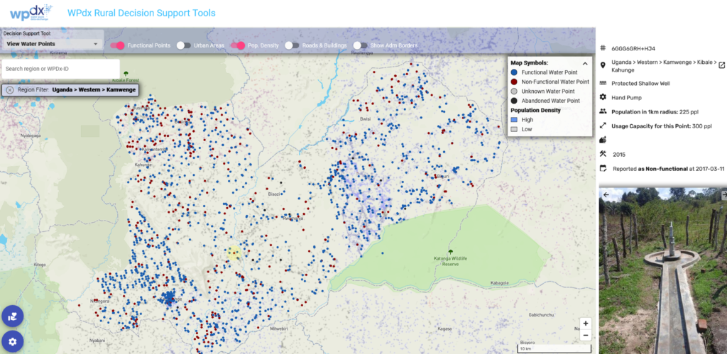
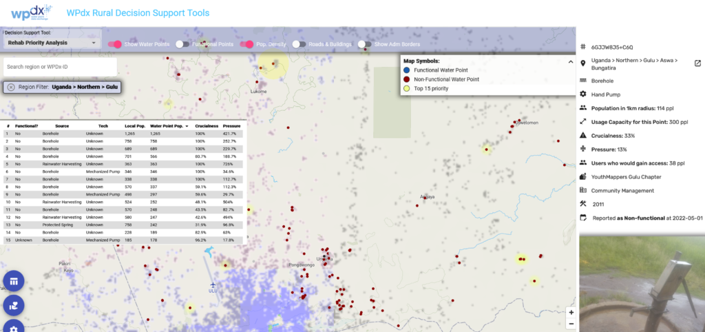
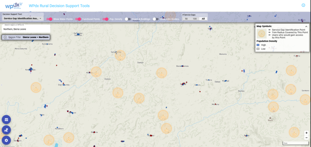
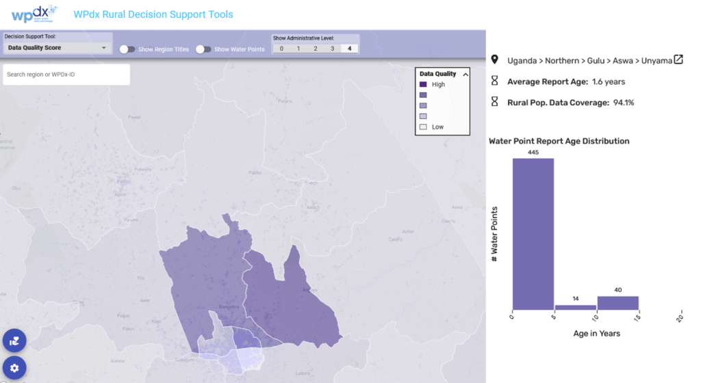
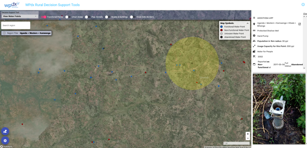
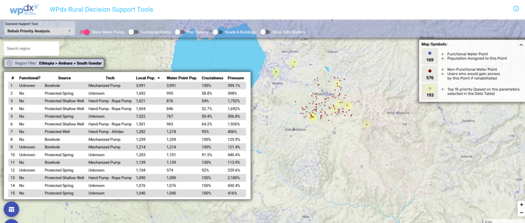
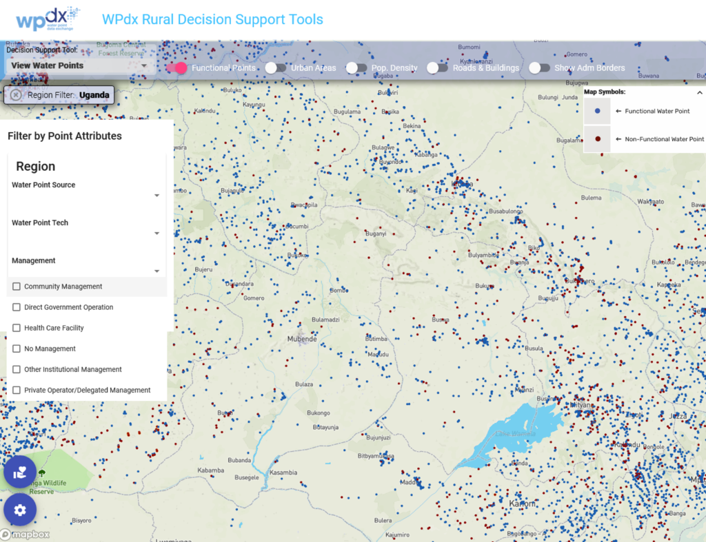
To address this gap, Global Water Challenge is developing the WASH Health Facility Data Exchange (WHdx), in partnership with Millennium Water Alliance (MWA) and with funding from the Conrad N. Hilton Foundation. This data exchange will offer a centralized data platform where health and WASH partners can routinely share and access data on WASH in healthcare facilities. The WHdx Decision-Support Tools will provide users with robust data visualization and analytics. WHdx will build on the lessons learned from the Water Point Data Exchange (WPdx) platform.

The WHdx Working Group, comprised of WASH in healthcare facilities experts, has guided the development process. Together they reviewed existing indicators from monitoring tools like WASH FIT and the JMP, as well as organization-specific tools, and identified those which were regularly collected, actionable, and scalable in order to create the WHdx data standard. The standard is now open for public comment through November 11, 2022.

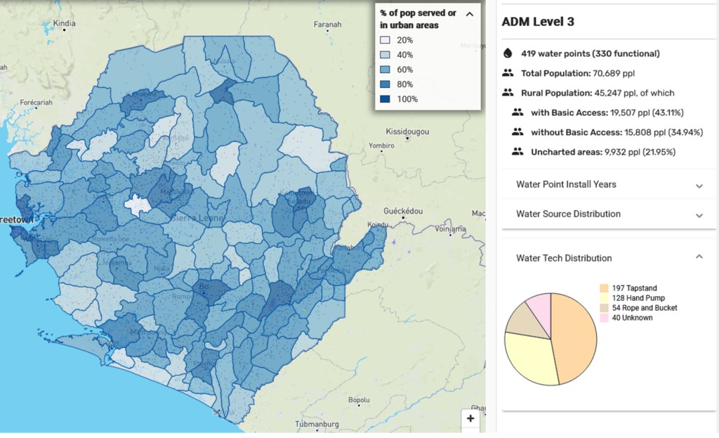
Ultimately, WHdx will offer users a harmonized WASH in healthcare facilities dataset that can be analyzed by JMP service ladder and key WASH FIT indicators, with granularity allowing for insights at the district- and facility-levels. The decision-making tools will provide estimates, recommendations, benchmarking, and impact evaluation to guide policymaking and investments. By better utilizing the data being collected, it is possible to generate greater operational efficiency and return on investment.

If you are interested in learning more and/or sharing data with the platform, please reach out to info@washhealthdata.org.

Using Meta’s High Resolution Population Density Estimates to Improve Rural Water Service Decisions

The Challenge: Dramatic acceleration needed to achieve SDGs

Today, 2 billion people lack access to safely managed drinking water services, including:

  • 1.2 billion people with basic services
  • 282 million with limited services
  • 367 million using unimproved sources
  • 122 million drinking surface water 

According to the United Nations, at our current rate of progress, universal access to drinking water – Sustainable Development Goal 6 (SDG 6) – will not be reached and in 2030, hundreds of millions of people will still spend their days collecting potentially unsafe drinking water. A key impediment to progress is the lack of quality information about rural water services and infrastructure.

Many low- and middle-income countries do not have up-to-date national inventories of rural water services due to the costs of regularly collecting data at scale. While the use of smartphones, tablets, and sensors by governments, NGOs, academics and others to


Basic services are defined as drinking water which is available from an improved source, such as a protected well or spring, within a 30 minute round trip including time for queuing.

An estimated 20-34% of water points in sub-Saharan Africa may be non-functional at any one time (Foster et. al, 2019).

collect data is increasing the amount of information gathered, often the data is difficult to access and – as the datasets live on individual computers or organizational servers – inconsistently formatted, not publicly available, or shared with appropriate audiences. Where raw data is available, the capacity needed to turn it into insights to improve decisions is often limited. This means that critical decisions about water services are being made without sufficient information.

The Opportunity: The Water Point Data Exchange (WPdx)

To address these challenges, Global Water Challenge developed the Water Point Data Exchange (WPdx) in 2015 to gather diverse rural water data focused primarily on improving basic water services. WPdx is designed to leverage data already being collected by key stakeholders and provides a flexible upload process to compile and harmonize shared data in a variety of common formats. 

WPdx hosts over 650,000 unique water point records from over 65 countries and 100 contributing organizations.

Governed by a working group of sector leaders, WPdx is funded by the Conrad N. Hilton Foundation and the Vitol Foundation. 

The WPdx platform has three core components:

  • SHARE: The WPdx Data Standard for data collection from individual water points or small water schemes;
  • ACCESS: A cloud-based global data library enabling access to harmonized global data compliant with the WPdx Data Standard; and 
  • USE: A suite of  decision support tools to guide policymakers and organizations to improve decision-making. Decision-support analyses are automatically run on a subset of data for countries which have nationally, or regionally representative data uploaded to WPdx. 

Critical to the Decision Support Tools is understanding the population density around each water point. To accomplish this, WPdx uses Meta’s high resolution population density data as an application layer. The Data for Good Program at Meta makes this data available publicly on the Humanitarian Data Exchange and AWS for more than 160 countries and territories around the globe.

“High quality population data is critical to making the best possible estimates of potential water point users. This information is vital to identifying priorities to ensure programs are designed to reach the most vulnerable populations which may otherwise be left behind.” 

                                                                                ~ Katy Sill, Ph.D., WASHdx Program Director Global Water Challenge


WPdx In Action

Across sub-Saharan Africa WPdx is being utilized to make critical financial and policy decisions about rehabilitating and building water facilities. A recent desk study demonstrated that compared to traditional approaches, using WPdx tools can more effectively prioritize unserved populations resulting in four times as many people being reached with a third less resources. In the Sierra Leone case study,  this equated to a per-person-reached cost reduction from $54.66 to $3.94.

In Ethiopia, the Millennium Water Alliance (MWA) has been implementing a five-year Water, Sanitation and Hygiene (WASH) Program in Dera, Farta and North Mecha woredas (districts) in the Amhara National Regional State (ANRS) since April 2019. With funding support from the Conrad N. Hilton Foundation, MWA and its program partners have prioritized water supply monitoring systems as one of the key program pillars. In 2020 WPdx was integrated into the programas a platform to compile updated government and NGO water point data to track SDG progress and support evidence-based decisions.

“The critical challenges in data management are scarcity, poor quality, and availability in different formats which are not easily usable.”

                         ~Tilik Tena, Researcher & Lecturer                                                                                                 Bahir Dar Institute of Technology Bahir Dar University

Since then, over 20,000 water point records from over 10 leading organizations have been uploaded and harmonized. The three target districts have a population of over 600,000 people, and there are plans to expand the use of WPdx across the Amhara region, home to over 20 million people.

So far, results from the WPdx decision support tools have been used by MWA and partners to

Attendees at a training in Amhara, Ethiopia login to the WPdx platform to upload data. Photo credit: Tedla Mulatu

prioritize investments. For instance, during the WASH program Annual Reflection and Learning Workshop, the tools compared the potential impact of existing water point rehabilitation versus resource allocation for the new water point construction. According to the government’s guidelines, water point rehabilitation must be done by user communities and NGOs are not advised to intervene in maintenance and rehabilitation.

However, by using the WPdx Rehabilitation Priority tool (which utilizes Meta’s high resolution population density data) to conduct a detailed analysis of the population that would benefit from new water supply system construction versus rehabilitation provided a convincing justification for the inclusion of water point rehabilitation support as core to the implementation plans.

“The role of Meta/Facebook in bringing people together across the different margins of the world to help look at one shared window is a phenomenal discovery. Its involvement in the WPdx platform which brings thousands of water point data together for learning-exchange, prediction and hence efficient management of scarce resources is another layer towards villagizing of the world. I am thrilled both by what has been done so far in Ethiopia to help decision makers start utilizing WPdx and also in the magnificent potential that WPdx platform brings to bridging the data management bottleneck in the WASH sector in Ethiopia.”                                                                     

                          ~Tedla Mulatu, Country Director                                                                                               Millennium Water Alliance Ethiopia

In Sierra Leone, through the establishment of the national Digital Monitoring Strategy and associated government directives, WPdx Decision Support Tools have been institutionalized across all water agencies. District Water Offices in Bombali and Port

Dr. Jonathan Tengbeh, Hon. Minister for Water Resources (2019) announced the national Digital WASH Monitoring Platform.

Loko districts (home to over 1,000,000 people) utilize the tools to inform work plans including the locations for water point rehabilitation and new construction. The Ministry of Water Resources is working with district water engineers and mapping officers to expand active use of WPdx to other districts. Priority locations are ranked by the number

of people potentially served by rehabilitated and/or new water points, estimated by using Meta’s high resolution population density dataset. Two population figures are calculated for each water point: a) number of people who live within a 1km radius from the water point (proxy for ‘basic water services’ definition per the UN/WHO Joint Monitoring Programme) and b) number of potential/likely users based on population and locations of other nearby water points. 

“Before WPdx, the selection of the location of water points was done by assumption and political decisions. Today, our district planning officers and national budget officers are using WPdx tools to reduce duplication and improve resource allocation in the country.”

                      ~Mohamed Bah, Head of Monitoring & Evaluation                                                                                         Sierra Leone Ministry of Water Resources

In Uganda, WPdx is partnering with USAID and YouthMappers to demonstrate the benefits of digitizing water point data collection. In collaboration with Gulu University and the Gulu YouthMappers chapter over 600 water point records, serving close to 10,000 people, were collected using KoboCollect, a customizable open-source

application used for primary data collection in humanitarian emergencies and other challenging circumstances. Data uploads to the WPdx platform were automated daily to provide an up-to-date view of the effort. The results of the data collection effort can be seen through the Administrative Region Analysis tool, which estimates the number of people with access to

Members of the Gulu YouthMappers chapter collect water point data in Uganda. Photo credit: Stella Nakacwa

functional and non-functional water points.

The analyses from the WPdx Decision Support Tools were shared with government, NGO and academic stakeholders who expressed interest in how the process could be used to more effectively collect and use water point data to improve service access. Discussions about a regional or national scaling of the effort to track progress towards the SDGs are ongoing. 

The U-WIMP project demonstrated how digitizing data collection allows information to be more rapidly shared compared to traditional paper-based methods. The WPdx platform helps to bring this data together and provides rapid analyses and visualizations to help provide a better understanding of the populations which currently have or lack access to available basic water services.”

                ~Courtney Clark, Program Director                                                                                          Everywhere She Maps, YouthMappers

Expanding to focus on WASH in Health Care Facilities

While WPdx continues to support programs in these and other countries a new platform, the  WASH in Health Facilities Data Exchange (WHdx) will be launched this year with similar datasets and tools to help accelerate improved WASH services at health care facilities around the world. 

Overview of WPdx Decision Support Tools

This section provides a brief summary of the WPdx decision-support tools used in the impact stories above.

View Water Points provides an  overview of available information for all water point records in WPdx. Also provides details for specific water points, including the point source, technology, location, and population within 1km of the water point.

Administrative Region Analysis – provides overview of the served, unserved, and uncharted populations for each available administrative division. Summarizes the distribution of water point source, technology, management type and installation years for a specific administartive region.

Rehabilitation Priority Analysis – provides ranked recommendations for the repair of non-functional water points to reach currently unserved populations. Estimates likely users per point based on population estimates and the proximity of other water points.

Service Gap/New Construction Priority Analysis – identifies locations for new service installation not within 1km of existing water points. Locations are ranked by the number of unserved people within 1km of the proposed locations. The tool may also provide insights on potential data gaps.

Data Quality Analysis – qualifies available data based on the age of available water point data and the coverage in terms of the percent of the total population living within 1km of water points included in the dataset on both point and administrative division scales.

Status Prediction Analysis – A new WPdx prediction model will soon be released to identify water points at highest risk of failure. The model utilizes data shared via the WPdx platform, population-based parameters calculated by WPdx, and external data which provides context for the environmental and demographic conditions around the water point. These external datasets include demographic data from Meta’s high resolution population density data as well as the Meta’s Relative Wealth Index.

For more information on WPdx or WHdx, please contact info@waterpointdata.org.

Global Water Challenge is a coalition of leading organizations deploying expertise and networks to achieve universal access to safe and affordable drinking water, sanitation, and hygiene (WASH) in communities around the world. Since 2006, GWC has positively impacted more than 2 million people across Africa, the Americas and Asia with clean water access. GWC’s actionable insight and innovative programs provide critical sector tools, data and best practices to reach millions more. With multi-sector partners, GWC engages for action – catalyzing financial resources and driving innovative programming for sustainable, local solutions. 

The Data for Good at Meta program provides privacy protecting data to assist in disaster response, health crises, poverty alleviation, and climate change. Eligible nonprofits and universities can apply for access to data on their website  www.dataforgood.facebook.com.

New Features Added to WPdx Decision Support Tools

We are excited to share some new features and updates which have been added to the WPdx decision support tools app.  Please take a few moments to check out the following:

New search feature

If you know the exact location you are interested in exploring, you can now type in the name of the country, region, district or sub-district (depending on what boundary information is available in WPdx) directly into the search bar in the upper left corner.

As you type, a list of options containing the requested text will appear below the text box. The video below shows how you can enter a country name (ie, Sierra Leone), a region (Northern), a district (Bombali) or a sub-district (Sella Limba) area and then zoom to that selected geography.

Depending on how unique the name of the area interest is, users may need to add some additional detail (i.e., Northern is a common administrative division name, so users may need to include the country of interest).

Users can also still use our existing ‘Filter by Region’ tool by clicking on the gear icon in the lower left corner and following the prompts.

Identification of water points which are abandoned or decommissioned

The #status_id parameter from the WPdx Data Standard requires users to provide a simple “Yes” or “No” to the question “Identify if any water is available on the day of the visit, recognizing that it may be a limited flow?”. 

While this simple classification is useful to compile and harmonize data which may have different thresholds for partial functionality, etc. it misses out on identifying water points which are non-functional due to abandonment or decommissioning. These designations are important, especially for analyses which focus on identifying priority water points for repair/rehabilitation.

Using the #status parameter, which is an open text field where users can provide additional information about the condition of the water point, we have classified water points as one of the following: Functional, Functional but in need of repair, Non-Functional, Non-Functional due to dry season, Abandoned/Decommissioned, and Other. We will continue to refine this cleaning process, and are in discussions with the WPdx Working Group to edit to the WPdx data standard to include ‘abandoned/decommissioned’ as a response to the #status_id parameter.

The Abandoned/Decommissioned points are still visible in the tools as black points (instead of red or blue points), but are not considered for the Administrative Region, Rehab Priority or Service Gap Identification analyses. The classifications are included in a new parameter “status_clean” which is available in the WPdx+ dataset.

Updated maximum capacity figures

For each water point, WPdx estimates the number of ‘likely users’ (for functional water points) or ‘users who could gain access’ (for non-functional water points) using high density population datasets from Meta (Facebook) and relative distance calculations if population centers have more than one water point within a 1km distance. This approach ensures that no one is double counted and that we have a reasonable estimate of how many people are using each specific water point. There is a maximum number of people who can be served by a single water point which is dependent on the water point technology. These maximum capacity figures vary by country.

Initially, WPdx tools utilized maximum capacity values primarily from the Sphere Guidelines. However, as these are designed as minimum standards during humanitarian assistance response, the figures were often  higher than national regulations for normal conditions. Through a consultative process with the WPdx working group and other external sector leaders, we have reduced the maximum capacities to the following figures:

  • 1000 people per mechanized (powered) well
  • 300 people per hand pump [most hand pumps except for those with listed lower capacities]
  • 250 people per tap (tapstand, kiosk)
  • 250 people per protected spring
  • 50 people per rainwater catchment system
  • 50 people per rope and bucket system/EMAS Pump/Rope Pump

These figures are intended to be reasonable estimates for a global algorithm. However, it may be possible to make make additional updates and customizations based on local regulations.

Please reach out to info@waterpointdata.org for more information.

Utilizing WPdx in the Amhara Region of Ethiopia

Contributed by Tedla Mulatu, Ethiopia Country Director, Millennium Water Alliance

The Millennium Water Alliance (MWA) has been implementing a five-year Water, Sanitation and Hygiene (WASH) Program in three target districts in Amhara National Regional State (ANRS) of Ethiopia since April 2019. With generous funding support and partnership from the Conrad N. Hilton Foundation, MWA and its program partners have prioritized water supply monitoring system as one of the key pillars of the five-year program. Other key program components include WASH in Health Care Facilities, WASH in Schools, Water Quality Improvement using Dispensers for Safe Water (DSW), Community Water Supply System Development and Capacity Development activities.

The Water Point Data Exchange (WPdx) has been included as a supplement to the WASH program since 2020 whereby the community level water monitoring data has been uploaded in the WPdx platform. Prior to uploading the water point data from the target districts, which include Dera, Farta, and North Mecha an appropriate process has been followed through MWA to secure the buy-in of the government of Ethiopia at all levels. Accordingly, the Water Development Commission granted a letter of support addressed to NGOs working in the WASH sector to share their respective water point data through the WPdx platform. This recommended step from the government has been a key milestone for MWA and Global Water Challenge (GWC) to collaborate further in training NGO and government partners on the utilization of WPdx with a focus on its decision support tools. The decision support tools of WPdx assist in the prioritization, resource allocation, and identifying target areas for water point construction and rehabilitation. The training and follow up support provided by MWA and GWC has resulted in the uploading of more than 20,000 water point data records from Ethiopia. [Please see this blog post which outlines the initial engagement with WPdx.]

Beyond supporting the upload of water point data, MWA has been spearheading the training and awareness creation about WPdx in Ethiopia. This engagement has included the use of WPdx decision support tools in the prioritization of activities for the upcoming Year IV Annual Plan (April 2022 – 2023). For instance, during the annual reflection and learning workshop convened by MWA, the decision support tools were utilized for the analysis of rehabilitation of existing water points versus resource allocation for the construction of new community water points. The discussion has been relevant to demonstrate the importance of rehabilitating existing water points to regional and district government. According to the government’s guidelines, rehabilitation of water points must be done by user communities and NGOs are not advised to intervene in the maintenance and rehabilitation work of community water points.

A specific case used for prioritization of rehabilitation over new water point construction has been in Dera district where Food for the Hungry (FH) implements a range of activities as part of the MWA collaborative program. Whereas ANRS has been skeptical about the intervention on water point rehabilitation and major maintenance support provided by FH in selected communities, the results presented and discussed provided a convincing justification for the inclusion of water point rehabilitation and major maintenance support through a detailed analysis of the number of beneficiary communities that would benefit from construction of new water supply system versus rehabilitation of existing water systems. FH has rehabilitated about 65 water sources for the past three years which benefited more than 15,700 community members within the woreda and also resulting in a reduction of non-functionality rate from 24% to 9.5%.

Whereas the government guidance is to build the capacity of water user communities to maintain and rehabilitate their water system, the analysis done has justified the importance of rehabilitating selected existing water system for selected communities. This plan was discussed and agreed during the annual reflection and learning workshop held in March 2022.

The WPdx Rehabilitation Priority Analysis calculates how many people would gain access to a specific water point if it were to return to a functional status and highlights top priorities based on selected criteria. Rehabilitation of existing water points is generally much more cost-effective than constructing new water points.

Integrating Governance Factors into WPdx

Governance is recognized as a key aspect of sustainable rural water services. The USAID Governance Research on Rural Water Systems (GROWS) activity was designed to identify and disseminate innovative governance and private sector-derived models and tools to improve water services to help accelerate eliminating extreme poverty in sub-Saharan Africa. GROWS was targeted to USAID Democracy, Human Rights and Governance (DRG) Officers at Missions across Africa to support increase cross-sectoral programing, leading to the enhancement of the delivery of rural water services. The final product of GROWS is a comprehensive toolkit which includes key research findings and program design support for USAID.

A key finding from GROWS was that the effective sharing of data at the community scale had the potential to improve the governance of local drinking water systems, due to greater levels of transparency, accountability and increased the trust between water users and providers. An extension of this finding is that sharing data from individual community water systems can strengthen district and/or regional governance by providing a comprehensive understanding of what is and is not working at different geographic scales.

The Water Point Data Exchange (WPdx) provides a free and open user-friendly platform for data sharing, access, and use, with the ultimate goal of supporting evidence-based decision-making. Through GROWS, WPdx added specific governance-oriented parameters and features to the WPdx+ dataset and decision-support tools app. This includes the integration of new governance-oriented datasets into our status prediction models. These datasets include:

Additionally, WPdx conducted increased data cleaning on the #management parameter to created standardized categories for management including: community based management, direct government operations, private/delegated management, health care facility management, school management, religious institution management, other institutional management, no management and unknown. Users can filter to view the results from the WPdx decision support tools by management type by selecting “Filter By Attribute” from the menu, as shown below:

The comprehensive WPdx user guide, which provides additional details about the platform is available here.

Comparing water point based and household survey based access estimates

Figure shows how DHS regions in Uganda (labeled) compared to WPdx regions (sub-counties from GADM) in red

What data should I use? Is the data valid? These are some of the driving questions facing decision makers around the world. Multiple sources of data are available to decision makers on the state of water access and services. There is relatively strong agreement that reliable data for decision making is needed. At the same time, it is not always clear which data sources are both available and appropriate to answer the questions about where and how to invest resources in water services and how to appropriately target the poorest.

With funding from the United States Agency for International Development (USAID) Governance Research on Water Systems (GROWS) activity, a study was commissioned to determine how water point coverage estimates based on publicly available data from the Water Point Data Exchange (WPdx) compare and contrast with the official Joint Monitoring Programme of WHO/UNICEF (JMP) figures. The goal is to provide recommendations about how these different estimates could be used in tandem and to identify their respective strengths and limitations. The study was carried out by Nick Dickinson of WASHNote.

Comparing between metrics and triangulating different measured results can be useful to validate conclusions and inform decision-making. This study finds a relatively strong correlation and linear trend between these two estimates in four countries that suggests that using household surveys and water point inventories together can be useful to decision makers who may only have one or the other data sources or may want to validate the conclusions from one against another.

The full paper has been submitted for peer review. A pre-print is available here. A link to the final paper will be added here once the paper has been accepted.

Acknowledgements from the Author, Nick Dickinson of WASHNote

This study would not have been possible without the contribution of open data on water points by data providers to WPdx. Members of the Water Point Data Exchange (WPdx) working group reviewed both the proposal and findings of this work. Katy Sill of WPdx first recognized the potential of the work, provided invaluable feedback, and responded quickly with explanations about how the WPdx algorithms work while investigating and delivering improvements to the tools when required to make this comparison possible.

Similarly, the National Statistics Offices (NSOs) and the Demographic and Health Surveys (DHS) Program of the United States Agency for International Development (USAID) made it possible to use household survey data from different countries. I would like to thank the Joint Monitoring Programme of WHO/UNICEF (JMP) team for sharing country, regional and global estimates of progress on drinking water, sanitation and hygiene (WASH) in households as well as the estimates for the sub-indicators required to generate those estimates, for providing clarifications about the JMP methodology, and for taking time to reflect on study findings.

This material is based upon work supported by USAID under award number 7200AA18CA00033.

Water point data and governance in Tanzania

With contributions from Herbert Kashililah, Chair, Tanzania Water and Sanitation Network (TAWASANET)

The United States Agency for International Development (USAID) Governance Research on Water Systems, or GROWS, is a research activity that focuses on rural water services as a lens through which to explore the interconnections between good governance and private sector engagement because of the critical role that water plays in community health and economic development.

A key finding from GROWS was that the effective sharing of data at the community scale had the potential to improve the governance of local drinking water systems, due to greater levels of transparency, accountability and increased the trust between water users and providers. An extension of this finding is that sharing data from individual community water systems can strengthen district and/or regional governance by providing a comprehensive understanding of what is and is not working at different geographic scales.

In February 2022, GROWS hosted a governance and water data workshop in Tanzania including participants from government, NGOs and development banks to explore current challenges and opportunities related to collecting, sharing, and using data at scale to improve rural water decision-making. The workshop included an active discussion focused on current data collection and analysis approaches as well as an introduction to the Water Point Data Exchange (WPdx) as a free and open platform which can enable data sharing, access and use.

Background

Water point mapping (WPM) to monitor the status of community water supplies has been part of the Tanzanian water management approach since 2004. Initiated by WaterAid and adopted by other key NGOs in the Tanzanian water sector (SNV, Plan International and Concern Worldwide), a widescale water point mapping exercise was held between 2005 and 2009 and resulted in the mapping of 55 of 132 rural water districts. Subsequently in 2010, the Government of Tanzania adopted WPM as its main tool for monitoring rural water supply and developed an online database, the Water Point Mapping System (WPMS). Between 2011 and 2013, the Ministry of Water mapped all districts in Tanzania mainland and data was uploaded to the WPMS. Since 2013, data has been updated on a district-by-district basis by government water managers.

Following the establishment of the Rural Water Supply and Sanitation Agency (RUWASA) in 2019, a new management information system has been created, the Rural Service Delivery Management Information System (RSDMS), which aims to support performance monitoring for both operation and governance needs of rural water investments. RSDMS is used to monitor and regulate construction and service provision for rural water and sanitation at district, regional and national levels.

Workshop Outcomes

Participants stated that accurate and up-to-date data on water point location, functionality, water quality, water tariffs, number of water users and presence of an active community-based water supply organizations (CBWSOs) were needed to allow for monitoring water point functionality.

Participants identified the following key challenges for implementing effective WPM: 1) collecting information from remote water points; 2) ensuring information is up to date; 3) handling issues with accurately coding unique water points; 4) handling challenges around data quality related to paper-based collection; and 5) holding data providers accountable.

Potential approaches to help overcome some of the identified WPM challenges included: 1) building technical capacity of CBWSOs; 2) engaging water users to provide information on water point functionality; 3) investing in hard-to-reach areas; and 4) advancing technological innovation to update the data collection systems.

Workshop participants were keen to learn more about WPdx and how the platform could be useful in compiling data to create a more up-to-date understanding of the rural water landscape and provide evidence-based insights to inform the decision-making process.

Sierra Leone Data Use Impact Desktop Study

Map image from Tonkolili showing investments made and WPdx recommendations.

A desktop study on the potential impact of data use in Sierra Leone was completed by Global Water Challenge for Akvo in support of the Data to Decisions program. A brief summary of the study is shared below, and the full report can be viewed here.

Objective
A common hypothesis is that using evidence to inform decisions regarding placement and repair of water points will lead to more impactful investments compared with traditional methods which rely heavily on political pressures and assumptions. The objective of this desktop study is to determine how many additional people could have theoretically received water services (defined as access to a functional water point within a 1km radius) if decisions about water point investments used evidence-based decision-support tools rather than traditional approaches in Sierra Leone.

Approach
This study focused on analyzing the number of people reached with water point investments made during 2012 in 12 districts in Sierra Leone in comparison with the number who might have been reached if the investment decisions had been driven by evidence. Twelve districts were included in the analysis: Bombali, Bo, Bonthe, Kailahun, Kambia, Kenema, Koinadugu, Kono, Moyamba, Port Loko, Pujehun, and Tonkolili.

Data from water point investments made prior to 2012 were downloaded from the Water Point Data Exchange (WPdx) database to provide a baseline of the data which could have been used to inform decisions made in 2012. Data from investments made in 2012 were also downloaded for the 12 districts from the WPdx database. The majority of data was provided by the Ministry of Water Resources, with additional contributions from non-governmental organizations (NGOs) working in Sierra Leone.

Using the evaluation and repair priority methods, the number of people reached by water point installations and rehabilitations from twelve districts in Sierra Leone were analyzed and compared with the number of people which could have been reached based on recommendations from the (first generation) WPdx decision-support tools. The 2012 Sierra Leone dataset did not clearly differentiate between rehabilitations and new constructions.

 Key Findings

From the available data, there were 1,561 water investments made in 2012, which reached a total of 28,556 people. Had WPdx data been available and used for making decisions on water investments in 2012, it would have been possible to reach nearly four times as many people with only about a third of the cost in water point investments. WPdx recommendations included 430 water point rehabilitation reaching 109,043 people. This is equivalent to a reduction in costs per-person reached from $54.66 to $3.94.

 The full study is available here.

Acknowledgements

With appreciation to Angela Cotugno for her assistance with the GIS analysis and Daniel Siegel for his contributions to the development of the first generation of WPdx geospatial decision support tools.

*Please note the study utilized the first generation of WPdx decision tools which have since been updated, though utilize similar algorithms.